|
| |
|---|---|
| <graph>
{ // // ATTENTION: This code is maintained at https://www.mediawiki.org/wiki/Template:Graph:Street_map_with_marks // Please do not modify it anywhere else, as it may get copied and override your changes. // Suggestions can be made at https://www.mediawiki.org/wiki/Template_talk:Graph:Street_map_with_marks // // Template translation is in https://commons.wikimedia.org/wiki/Data:Original/Template:Graphs.tab // "version": 2, "width":280, "height": 250, "padding": 0, "signals":[ // These signals allow us to quickly move the map within the image, e.g. to leave space for the legend{"name":"legendWidth", "init": {"expr": "0"} }, {"name":"legendHeight", "init": {"expr": "height"} }, {"name":"imgWidth", "init": {"expr": "width-legendWidth"} }, {"name":"imgHeight", "init": {"expr": "height"} }, {"name":"imgXC", "init": {"expr": "imgWidth/2"} }, {"name":"imgYC", "init": {"expr": "imgHeight/2"} }, {"name":"imgTileSize", "init": {"expr": "256"} }, {"name":"imgLat", "init": {"expr": "51.3167"} }, {"name":"imgLon", "init": {"expr": "9.4"} }, {"name":"imgZoom", "init": {"expr": "5"} }, {"name":"picWidth", "init": {"expr": "180"} }, {"name":"picHeight", "init": {"expr": "picWidth/2"} }, {"name":"picXC", "init": {"expr": "imgWidth-(picWidth/2)"} }, {"name":"picYC", "init": {"expr": "imgHeight-(picHeight/2)"} }, {"name":"showMiniMap", "init": {"expr": "0"} }, ], "data": [ { "name": "data",// Otherwise use the first unnamed argument for source values "values": [{ "lat": 51.3167, "lon": 9.4, "img": "wikirawupload://upload.wikimedia.org/wikipedia/commons/thumb/1/10/Mapscaleline.svg/120px-Mapscaleline.svg.png", "width": 50, "height": 8, "offsetX": 103, "offsetY": 115, "textAlign": "right", "textDx": 22, "textDy": -2, "textColor": "grey", "textFont": "Tahoma", "textFontSize": 9, "text": "200km" }, { "lat": 51.3167, "lon": 9.4, "img": "wikirawupload://upload.wikimedia.org/wikipedia/commons/thumb/0/0c/Red_pog.svg/8px-Red_pog.svg.png", "height": 8, "width": 8, "text": "", "textAlign": "right", "textBaseline": "middle", "textDx": -6, "textDy": 0+1, "textFontSize": 14
}
// Legend only works if showLegend and colorScaleField are set "marks": [ { "type": "image", "from": { "data": "dummyData", "transform": [ { "type": "formula", "field":"url", "expr": "'mapsnapshot:///?width='+imgWidth+'&height='+imgHeight+'&zoom='+imgZoom+'&lat='+imgLat+'&lon='+imgLon" } ] }, "properties": { "enter": { "url": {"field": "url"}, "xc": {"signal": "imgXC"}, "yc": {"signal": "imgYC"}, "width": {"signal": "imgWidth"}, "height": {"signal": "imgHeight"} } } }, { // Places an image of a given name and size at the [lan,lon] location "type": "image", "from": { "data": "data", "transform": [ { "type": "filter", "test": "datum.img" }, { "type": "formula", "field":"iconWidth", "expr": "datum.width || 0" }, { "type": "formula", "field":"iconHeight", "expr": "datum.height || 0" }, { "type": "formula", "field":"img", "expr": "if(!test(/^[a-z]+:\\/\\//, datum.img), 'wikifile:///'+datum.img, datum.img)" }, // Ensure that either width or height parameter is passed to wikifile:// request { "type": "formula", "field":"img", "expr": "if((datum.iconWidth || datum.iconHeight) && !test(/[?&](width|height)=\\d/, datum.img),if(datum.iconWidth,datum.img+'?width='+datum.iconWidth,datum.img+'?height='+datum.iconHeight), datum.img)" }, ]}, "properties": { "enter": { "url": {"field": "img"}, "xc": {"field": "layout_x"}, "yc": {"field": "layout_y"}, "width": {"field": "iconWidth"}, "height": {"field": "iconHeight"} } } }, { // Draw marks of a given color, shape, and size at the [lan,lon] location "type": "symbol", "from": { "data": "data", "transform": [{ "type": "filter", "test": "!datum.img" }] }, "properties": { "enter": { "x": {"field": "layout_x"}, "y": {"field": "layout_y"}, // If colorScaleField is set, use color scaling, otherwise use the preset color value "fill": { "field": "color" }, "size": {"field": "size"}, "shape": {"field": "shape"}, "stroke": {"field": "strokeColor"} } } }, { // Draw text with the given color and size at the [lan,lon] location // See https://github.com/vega/vega/wiki/Marks#text for all parameter description (prepend "text" and capitalize them) "type": "text", "from": { "data": "data", "transform": [ { "type": "filter", "test": "datum.text" }, // Figure out if this is an LTR or RTL page. For LTR, show label to the right of the icon, left-aligned. For RTL, reverse. { "type": "formula", "field":"isLTR", "expr": "'' == '\\u200E'" }, // If these values are not defined ("undefined" is not allowed, so test for truthiness and not 0) { "type": "formula", "field":"textDx", "expr": "if(!datum.textDx && datum.textDx != 0, if(datum.isLTR,8,-8), datum.textDx)" }, { "type": "formula", "field":"textAlign", "expr": "if(!datum.textAlign, if(datum.isLTR,'left','right'), datum.textAlign)" }, { "type": "formula", "field":"textBaseline", "expr": "datum.textBaseline || 'middle'" } ]}, "properties": { "enter": { "text": {"field": "text"}, "x": {"field": "layout_x" }, "y": {"field": "layout_y"}, "dx": {"field": "textDx" }, "dy": {"field": "textDy"}, "fill": {"field": "textColor"}, "align": {"field": "textAlign"}, "baseline": {"field": "textBaseline"}, "radius": {"field": "textRadius"}, "theta": {"field": "textTheta"}, "angle": {"field": "textAngle"}, "font": {"field": "textFont"}, "fontSize": {"field": "textFontSize"}, "fontWeight": {"field": "textFontWeight"}, "fontStyle": {"field": "textFontStyle"} } } }, { // Draw a low-zoom locator map frame "type": "rect", "from": { "data": "dummyData", "transform": [ { "type": "filter", "test": "showMiniMap" } ] }, "properties": { "enter": { "xc": {"signal": "picXC"}, "yc": {"signal": "picYC"}, "width": {"signal": "picWidth", "offset":2}, "height": {"signal": "picHeight"}, "stroke": {"value":"#fff"},"strokeWidth": {"value":6}, } } }, { // Draw a low-zoom locator map by using a premade world map image "type": "image", "from": { "data": "dummyData", "transform": [ { "type": "filter", "test": "showMiniMap" }, { "type": "formula", "field":"url", "expr": "1" } ] }, "properties": { "enter": { "url": {"value": "wikirawupload://upload.wikimedia.org/wikipedia/commons/thumb/c/c4/Earthmap1000x500compac.jpg/180px-Earthmap1000x500compac.jpg"}, "xc": {"signal": "picXC"}, "yc": {"signal": "picYC"}, "width": {"signal": "picWidth"}, "height": {"signal": "picHeight"} } } }, { // Draw a zoom-out mark at the [lan,lon] location "type": "symbol", "from": { "data": "dummyData", "transform": [ { "type": "filter", "test": "showMiniMap" }, { "type": "formula", "field":"lat", "expr": "imgLat" }, { "type": "formula", "field":"lon", "expr": "imgLon" }, { "type": "geo", "projection": "equirectangular", "scale": {"expr": "180/2/PI"}, "translate": [{"expr": "picXC"}, {"expr": "picYC"}], "center": [{"expr": "0"}, {"expr": "0"}], "lon": "lon", "lat": "lat" } ] }, "properties": { "enter": { "x": {"field": "layout_x"}, "y": {"field": "layout_y"}, "fill": {"value": "#c33"}, "stroke": {"value": "#ffe7e6"}, "size": {"value": 40} } } } ]} </graph> <maplink zoom="6" latitude="51.3167" longitude="9.4" text="[كامل الشاشة]">
[
|
<tr>
<td colspan="2"><tr>
<td colspan="2" style="text-align:center;background-color:#F9F9F9;color:#000000;">* اسم الموقع كما هو مدون بقائمة مواقع التراث العالمي
** تقسييم اليونسكو لمناطق العالم
<tr>
<td class="navigation-only" colspan="2" style="border-top: 2px #5b92e5 dotted; font-size: 80%; background:inherit; text-align: left;">تعديل طالع توثيق القالب</td>
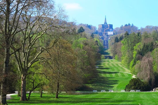
بيرغبارك فيلهلمشوه هي حديقة مناظر طبيعية في كاسل، ألمانيا. منطقة الحديقة تبلغ 2.4 كيلو متر مربع (590 أكر)، والذي يجعلها أكبر حديقة مبنية على تلة في أوروبا، وثاني أكبر حديقة مبنية على تلة في العالم. بدء بناء بيرغبارك أو "حديقة الجبل" في 1696 بتوصية من لاندغريفية هسن كاسل واستغرقت 150 عام لكي تكتمل. الحديقة مفتوحة إلي العامة الآن. أصبحت منذ 2013 موقع تراث عالمي في اليونيسكو.
بيرغبارك فيلهلمشوه، من وسط مدينة كاسل
فنون الماء ، مضاءة في الليل
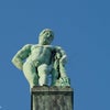
تمثال هرقل أعلى المثمن ، خلال التجديد في عام 2011
بيرغبارك فيلهلمشوه، مشهد جانبي من نُصب هرقل
مشهد قريب من نُصب هرقل
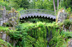
قنطرة شولينين (قنطرة الشيطان)
شلال اصطناعي
اللوزينبرغ (قلعة الأسد)
بيرغبارك فيلهلمشوه، ورقة توضح أن عملية التجديد لا تزال جارية في عام 2013
"واسنكرسيت" يتم مشاهدته من قِبل السياح، 2016
تصنيف:مقالات مشروع 600 ألف مقالة
تصنيف:قالب تصنيف كومنز بوصلة كما في ويكي بيانات
تصنيف:حدائق في ألمانيا تصنيف:لاندغريفية هسن كاسل تصنيف:مبان ومنشآت في كاسل تصنيف:معالم في ألمانيا تصنيف:مناطق محمية في هسن تصنيف:مواقع التراث العالمي في ألمانيا